


Pontarlier Rando OVS

TRIMAILLE
User
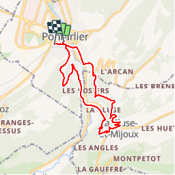

Length
15.3 km

Max alt
1064 m

Uphill gradient
544 m
Km-Effort
23 km

Min alt
827 m

Downhill gradient
545 m
Boucle
No
Creation date :
2019-11-29 16:56:55.787
Updated on :
2019-11-29 16:57:48.905
4h42
Difficulty : Medium

FREE GPS app for hiking
 SityTrail
IGN / Geographical institutes
SityTrail Plus
The world is yours!
About
Trail Walking of 15.3 km to be discovered at Bourgogne-Franche-Comté, Doubs, Pontarlier. This trail is proposed by TRIMAILLE.
Positioning
Country:
France
Region :
Bourgogne-Franche-Comté
Department/Province :
Doubs
Municipality :
Pontarlier
Location:
Unknown
Start:(Dec)
Start:(UTM)
298127 ; 5197582 (32T) N.
Comments