


Saussis ST Hippolyte Saussis 15 avril 2018 OVS

TRIMAILLE
User
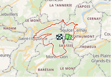

Length
18.9 km

Max alt
752 m

Uphill gradient
775 m
Km-Effort
29 km

Min alt
370 m

Downhill gradient
780 m
Boucle
Yes
Creation date :
2019-11-29 17:45:18.941
Updated on :
2021-02-01 10:40:37.553
6h02
Difficulty : Difficult

FREE GPS app for hiking
 SityTrail
IGN / Geographical institutes
SityTrail Plus
The world is yours!
About
Trail Walking of 18.9 km to be discovered at Bourgogne-Franche-Comté, Doubs, Montandon. This trail is proposed by TRIMAILLE.
Description
Le point de départ est à ST Hippolyte
Positioning
Country:
France
Region :
Bourgogne-Franche-Comté
Department/Province :
Doubs
Municipality :
Montandon
Location:
Unknown
Start:(Dec)
Start:(UTM)
337256 ; 5242251 (32T) N.
Comments