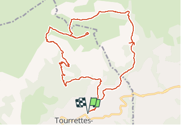
![](/images/other/stat-length.png)
![Trail Walking Tourrettes-sur-Loup - Puy de Naouri - Photo](https://media.geolcdn.com/t/1900/400/ext.pjpeg?maxdim=2&url=https%3A%2F%2Fmedia.geolcdn.com%2Ff%2F2c7796bd-9797-45f1-9868-6f05f50dfe9c.jpg)
Puy de Naouri
domi06
User
![Length](/images/other/stat-length.png)
![Max alt](https://static1.geolcdn.com/siteimages/upload/files/1508320355ic_sort_altitude_max_24dp.png)
![Uphill gradient](https://static1.geolcdn.com/siteimages/upload/files/1508320355ic_sort_den_pos_24dp.png)
![Km-Effort](/images/other/stat-length.png)
![Min alt](https://static1.geolcdn.com/siteimages/upload/files/1508320355ic_sort_altitude_min_24dp.png)
![Downhill gradient](https://static1.geolcdn.com/siteimages/upload/files/1508320355ic_sort_den_neg_24dp.png)
![Boucle](https://static1.geolcdn.com/siteimages/upload/files/16400158638029165_repeat_loop_refresh_sync_direction_icon.png)
![Walking](https://static1.geolcdn.com/sitytour/trail-icons/101.png)
6h00
Difficulty : Medium
![Scan this QR Code to open this trail in the SityTrail application](https://capi.geolives.com/qq0zvz2zws4bq2lad0pu/sitytour/trails/2275513/qr.png?size=200)
FREE GPS app for hiking
About
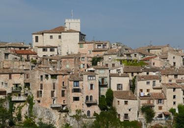
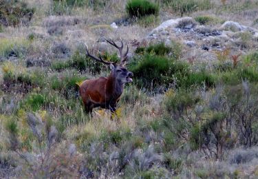
Trail Walking of 13.6 km to be discovered at Provence-Alpes-Côte d'Azur, Maritime Alps, Tourrettes-sur-Loup. This trail is proposed by domi06.
Description
RanOxygène
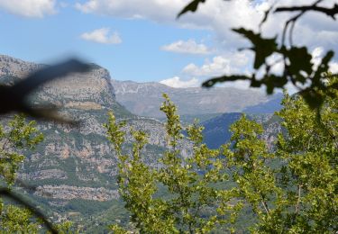
Du parking d’entrée du Pré Neuf (400 mètres - b.170 Tourrettes Sur Loup), suivre vers l’Est la petite route des Virettes qui s’élève dans un quartier résidentiel (b.171) parvenu au vallon de Notre-Dame, continuer par un large chemin (b.116) en forêt qui rejoint l'itinéraire de la chapelle St-Raphaël et des ruines des Malvans.
Poursuivre en direction de celles-ci, puis par un sentier de niveau rejoindre le gué du Malvan (b.114).
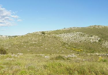
Remonter à gauche (Ouest) la combe de Maigré qu’on quitte bientôt (b.115) au profit de la combe de la Baisse (à gauche). Un sentier plus étroit et raide mène à un collet évident (988 mètres - b.178) ; effectuer vers l’est un rapide aller-retour jusqu’au sommet du puy de Naouri (1 024 mètres).
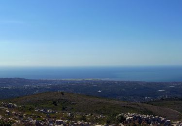
Cheminer ensuite vers l’ouest sur la crête panoramique (légère montée) avant de plonger (b.176) en versant Sud sur le domaine du Caire qu’on contourne par l’est (b.175a, prière de bien refermer les barrières à chevaux).
Descendre alors 2 kilomètres sur la route (b. 175b) sinueuse du Caire (b.174) avant de prendre à gauche (b.173) un sentier de niveau qui ramène au quartier des Virettes (b.172) ; une petite route à forte déclivité (b.171) conduit rapidement au parking de départ.
Positioning
Comments
Trails nearby
![Trail Walking Tourrettes-sur-Loup - Le Puy de Naouri 1024 m, depuis Tourrettes-sur-Loup - Photo](https://media.geolcdn.com/t/375/260/ext.jpg?maxdim=2&url=https%3A%2F%2Fservices.sitytrail.com%2FGeolivesWS%2FDownloadMedia.ashx%3FTrailID%3D214858%26Media%3D15396_1.jpg)
![Walking Walking](https://static1.geolcdn.com/sitytour/trail-icons/101.png)
Walking
![](/images/other/stat-length.png)
![](https://static1.geolcdn.com/siteimages/upload/files/16400158638029165_repeat_loop_refresh_sync_direction_icon.png)
![Trail On foot Vence - Circuit des Blaquières - Photo](https://media.geolcdn.com/t/375/260/ext.jpg?maxdim=2&url=https%3A%2F%2Fmedia.geolcdn.com%2Ff%2F46014005-cf89-423b-a650-f449be44d3f6.jpeg)
![On foot On foot](https://static1.geolcdn.com/sitytour/trail-icons/100.png)
On foot
![](/images/other/stat-length.png)
![](https://static1.geolcdn.com/siteimages/upload/files/16400158638029165_repeat_loop_refresh_sync_direction_icon.png)
![Trail On foot Tourrettes-sur-Loup - Circuit de Pié Martin - Photo](https://media.geolcdn.com/t/375/260/ext.jpg?maxdim=2&url=https%3A%2F%2Fmedia.geolcdn.com%2Ff%2F6e40e7c0-6b09-4a1a-a532-91e02b70ea94.jpeg)
![On foot On foot](https://static1.geolcdn.com/sitytour/trail-icons/100.png)
On foot
![](/images/other/stat-length.png)
![](https://static1.geolcdn.com/siteimages/upload/files/16400158638029165_repeat_loop_refresh_sync_direction_icon.png)
![Trail On foot Le Rouret - Le Camp romain - Photo](https://media.geolcdn.com/t/375/260/ext.jpg?maxdim=2&url=https%3A%2F%2Fmedia.geolcdn.com%2Ff%2Fd6aefa76-dc44-4fc7-8d77-d19148310732.jpeg)
![On foot On foot](https://static1.geolcdn.com/sitytour/trail-icons/100.png)
On foot
![](/images/other/stat-length.png)
![](https://static1.geolcdn.com/siteimages/upload/files/16400158638029165_repeat_loop_refresh_sync_direction_icon.png)
![Trail On foot Courmes - Plateau de Saint-Barnabé - Photo](https://media.geolcdn.com/t/375/260/ext.jpg?maxdim=2&url=https%3A%2F%2Fmedia.geolcdn.com%2Ff%2Fe5884674-6345-4525-aa20-82da8aac2558.jpeg)
![On foot On foot](https://static1.geolcdn.com/sitytour/trail-icons/100.png)
On foot
![](/images/other/stat-length.png)
![](https://static1.geolcdn.com/siteimages/upload/files/16400158638029165_repeat_loop_refresh_sync_direction_icon.png)
![Trail On foot Vence - Circuit du Malvan - Photo](https://media.geolcdn.com/t/375/260/ext.jpg?maxdim=2&url=https%3A%2F%2Fmedia.geolcdn.com%2Ff%2Fa11b075b-d314-4d7d-9ea3-2c9f013025ba.jpeg)
![On foot On foot](https://static1.geolcdn.com/sitytour/trail-icons/100.png)
On foot
![](/images/other/stat-length.png)
![](https://static1.geolcdn.com/siteimages/upload/files/16400158638029165_repeat_loop_refresh_sync_direction_icon.png)
![Trail On foot Vence - Plan des Noves - Photo](https://media.geolcdn.com/t/375/260/ext.jpg?maxdim=2&url=https%3A%2F%2Fmedia.geolcdn.com%2Ff%2F5bdbad17-ece4-4950-8e82-290491f5430d.jpeg)
![On foot On foot](https://static1.geolcdn.com/sitytour/trail-icons/100.png)
On foot
![](/images/other/stat-length.png)
![](https://static1.geolcdn.com/siteimages/upload/files/16400158638029165_repeat_loop_refresh_sync_direction_icon.png)
![Trail On foot Tourrettes-sur-Loup - Puy de Naouri - Photo](https://media.geolcdn.com/t/375/260/ext.jpg?maxdim=2&url=https%3A%2F%2Fmedia.geolcdn.com%2Ff%2Fa11b075b-d314-4d7d-9ea3-2c9f013025ba.jpeg)
![On foot On foot](https://static1.geolcdn.com/sitytour/trail-icons/100.png)
On foot
![](/images/other/stat-length.png)
![](https://static1.geolcdn.com/siteimages/upload/files/16400158638029165_repeat_loop_refresh_sync_direction_icon.png)
![Trail Walking Vence - Vence le Baou des Blancs - Photo](https://media.geolcdn.com/t/375/260/ext.jpg?maxdim=2&url=https%3A%2F%2Fservices.sitytrail.com%2FGeolivesWS%2FDownloadMedia.ashx%3FTrailID%3D168755%26Media%3D20130105141841.jpeg)
![Walking Walking](https://static1.geolcdn.com/sitytour/trail-icons/101.png)
Walking
![](/images/other/stat-length.png)
![](https://static1.geolcdn.com/siteimages/upload/files/16400158638029165_repeat_loop_refresh_sync_direction_icon.png)