


Parc National de Gaspésie

TRIMAILLE
User
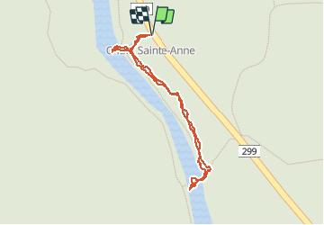

Length
955 m

Max alt
242 m

Uphill gradient
10 m
Km-Effort
1.1 km

Min alt
233 m

Downhill gradient
9 m
Boucle
Yes
Creation date :
2019-12-01 09:38:52.18
Updated on :
2021-01-31 16:14:57.056
52m
Difficulty : Easy

FREE GPS app for hiking
 SityTrail
IGN / Geographical institutes
SityTrail Plus
The world is yours!
About
Trail Walking of 955 m to be discovered at Quebec, La Haute-Gaspésie, Mont-Albert. This trail is proposed by TRIMAILLE.
Positioning
Country:
Canada
Region :
Quebec
Department/Province :
La Haute-Gaspésie
Municipality :
Mont-Albert
Location:
Unknown
Start:(Dec)
Start:(UTM)
710644 ; 5424854 (19U) N.
Comments