


Mt Ernest Laforce Parc de Gaspésie

TRIMAILLE
User
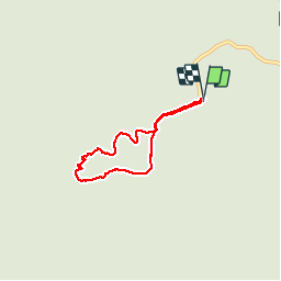

Length
5 km

Max alt
830 m

Uphill gradient
184 m
Km-Effort
7.5 km

Min alt
651 m

Downhill gradient
180 m
Boucle
Yes
Creation date :
2019-12-01 09:40:43.76
Updated on :
2019-12-01 09:41:55.862
1h33
Difficulty : Easy

FREE GPS app for hiking
 SityTrail
IGN / Geographical institutes
SityTrail Plus
The world is yours!
About
Trail Walking of 5 km to be discovered at Quebec, La Haute-Gaspésie, Mont-Albert. This trail is proposed by TRIMAILLE.
Positioning
Country:
Canada
Region :
Quebec
Department/Province :
La Haute-Gaspésie
Municipality :
Mont-Albert
Location:
Unknown
Start:(Dec)
Start:(UTM)
715153 ; 5423245 (19U) N.
Comments