


Gaspé Tour du Mt Alban

TRIMAILLE
User
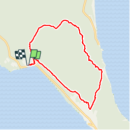

Length
8.2 km

Max alt
284 m

Uphill gradient
350 m
Km-Effort
12.9 km

Min alt
3 m

Downhill gradient
350 m
Boucle
Yes
Creation date :
2019-12-01 09:50:51.356
Updated on :
2019-12-01 09:51:45.97
2h39
Difficulty : Easy

FREE GPS app for hiking
 SityTrail
IGN / Geographical institutes
SityTrail Plus
The world is yours!
About
Trail Walking of 8.2 km to be discovered at Quebec, La Côte-de-Gaspé, Gaspé. This trail is proposed by TRIMAILLE.
Positioning
Country:
Canada
Region :
Quebec
Department/Province :
La Côte-de-Gaspé
Municipality :
Gaspé
Location:
Unknown
Start:(Dec)
Start:(UTM)
408581 ; 5406563 (20U) N.
Comments