


SityTrail - boucq Luc 26 06 19

ZAMBAUX
User
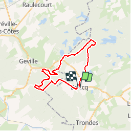

Length
24 km

Max alt
389 m

Uphill gradient
405 m
Km-Effort
29 km

Min alt
234 m

Downhill gradient
390 m
Boucle
Yes
Creation date :
2019-12-01 10:19:33.952
Updated on :
2019-12-01 10:23:00.597
6h17
Difficulty : Very difficult

FREE GPS app for hiking
 SityTrail
IGN / Geographical institutes
SityTrail Plus
The world is yours!
About
Trail Walking of 24 km to be discovered at Grand Est, Meurthe-et-Moselle, Boucq. This trail is proposed by ZAMBAUX.
Description
Rando que l'on peut réduire facilement


Positioning
Country:
France
Region :
Grand Est
Department/Province :
Meurthe-et-Moselle
Municipality :
Boucq
Location:
Unknown
Start:(Dec)
Start:(UTM)
703114 ; 5402990 (31U) N.
Comments