


Cernans Rando OVS

TRIMAILLE
User
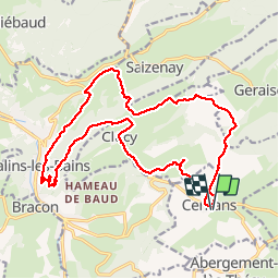

Length
22 km

Max alt
688 m

Uphill gradient
655 m
Km-Effort
31 km

Min alt
379 m

Downhill gradient
655 m
Boucle
Yes
Creation date :
2019-12-01 13:29:56.969
Updated on :
2019-12-01 13:30:51.632
6h35
Difficulty : Difficult

FREE GPS app for hiking
 SityTrail
IGN / Geographical institutes
SityTrail Plus
The world is yours!
About
Trail Walking of 22 km to be discovered at Bourgogne-Franche-Comté, Jura, Cernans. This trail is proposed by TRIMAILLE.
Positioning
Country:
France
Region :
Bourgogne-Franche-Comté
Department/Province :
Jura
Municipality :
Cernans
Location:
Unknown
Start:(Dec)
Start:(UTM)
723291 ; 5201701 (31T) N.
Comments