


Rouffange rando CAF

TRIMAILLE
User
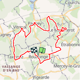

Length
22 km

Max alt
323 m

Uphill gradient
554 m
Km-Effort
29 km

Min alt
208 m

Downhill gradient
556 m
Boucle
Yes
Creation date :
2019-12-01 13:34:59.789
Updated on :
2019-12-01 13:35:50.073
6h12
Difficulty : Difficult

FREE GPS app for hiking
 SityTrail
IGN / Geographical institutes
SityTrail Plus
The world is yours!
About
Trail Walking of 22 km to be discovered at Bourgogne-Franche-Comté, Jura, Rouffange. This trail is proposed by TRIMAILLE.
Positioning
Country:
France
Region :
Bourgogne-Franche-Comté
Department/Province :
Jura
Municipality :
Rouffange
Location:
Unknown
Start:(Dec)
Start:(UTM)
704871 ; 5233570 (31T) N.
Comments