


Rupt-sur-Saône rando CAF

TRIMAILLE
User
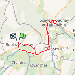

Length
17.5 km

Max alt
238 m

Uphill gradient
215 m
Km-Effort
20 km

Min alt
198 m

Downhill gradient
223 m
Boucle
Yes
Creation date :
2019-12-01 14:10:00.774
Updated on :
2019-12-01 14:10:51.431
4h27
Difficulty : Difficult

FREE GPS app for hiking
 SityTrail
IGN / Geographical institutes
SityTrail Plus
The world is yours!
About
Trail Walking of 17.5 km to be discovered at Bourgogne-Franche-Comté, Haute-Saône, Rupt-sur-Saône. This trail is proposed by TRIMAILLE.
Positioning
Country:
France
Region :
Bourgogne-Franche-Comté
Department/Province :
Haute-Saône
Municipality :
Rupt-sur-Saône
Location:
Unknown
Start:(Dec)
Start:(UTM)
720106 ; 5281305 (31T) N.
Comments