


Larnod rando CAF

TRIMAILLE
User
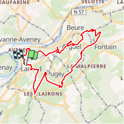

Length
22 km

Max alt
503 m

Uphill gradient
602 m
Km-Effort
30 km

Min alt
301 m

Downhill gradient
602 m
Boucle
Yes
Creation date :
2019-12-01 14:11:46.857
Updated on :
2019-12-01 14:12:41.591
6h18
Difficulty : Difficult

FREE GPS app for hiking
 SityTrail
IGN / Geographical institutes
SityTrail Plus
The world is yours!
About
Trail Walking of 22 km to be discovered at Bourgogne-Franche-Comté, Doubs, Larnod. This trail is proposed by TRIMAILLE.
Positioning
Country:
France
Region :
Bourgogne-Franche-Comté
Department/Province :
Doubs
Municipality :
Larnod
Location:
Unknown
Start:(Dec)
Start:(UTM)
724960 ; 5230422 (31T) N.
Comments