


oster

Chanchan63
User
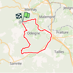

Length
23 km

Max alt
660 m

Uphill gradient
503 m
Km-Effort
30 km

Min alt
420 m

Downhill gradient
503 m
Boucle
Yes
Creation date :
2019-12-01 09:06:01.994
Updated on :
2019-12-01 14:23:32.108
5h15
Difficulty : Very easy

FREE GPS app for hiking
 SityTrail
IGN / Geographical institutes
SityTrail Plus
The world is yours!
About
Trail Walking of 23 km to be discovered at Wallonia, Luxembourg, Manhay. This trail is proposed by Chanchan63.
Positioning
Country:
Belgium
Region :
Wallonia
Department/Province :
Luxembourg
Municipality :
Manhay
Location:
Odeigne
Start:(Dec)
Start:(UTM)
689334 ; 5572435 (31U) N.
Comments