


Devecey rando OVS

TRIMAILLE
User
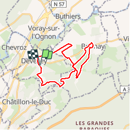

Length
13.8 km

Max alt
441 m

Uphill gradient
345 m
Km-Effort
18.4 km

Min alt
217 m

Downhill gradient
346 m
Boucle
Yes
Creation date :
2019-12-01 14:36:12.987
Updated on :
2019-12-01 14:37:28.432
3h55
Difficulty : Medium

FREE GPS app for hiking
 SityTrail
IGN / Geographical institutes
SityTrail Plus
The world is yours!
About
Trail Walking of 13.8 km to be discovered at Bourgogne-Franche-Comté, Doubs, Devecey. This trail is proposed by TRIMAILLE.
Positioning
Country:
France
Region :
Bourgogne-Franche-Comté
Department/Province :
Doubs
Municipality :
Devecey
Location:
Unknown
Start:(Dec)
Start:(UTM)
274503 ; 5245586 (32T) N.
Comments