


Bians-les-Usiers - rando CAF

TRIMAILLE
User
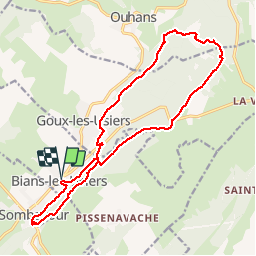

Length
19.8 km

Max alt
910 m

Uphill gradient
486 m
Km-Effort
26 km

Min alt
670 m

Downhill gradient
485 m
Boucle
Yes
Creation date :
2019-12-01 14:38:53.19
Updated on :
2019-12-01 14:39:48.096
5h35
Difficulty : Difficult

FREE GPS app for hiking
 SityTrail
IGN / Geographical institutes
SityTrail Plus
The world is yours!
About
Trail Walking of 19.8 km to be discovered at Bourgogne-Franche-Comté, Doubs, Bians-les-Usiers. This trail is proposed by TRIMAILLE.
Positioning
Country:
France
Region :
Bourgogne-Franche-Comté
Department/Province :
Doubs
Municipality :
Bians-les-Usiers
Location:
Unknown
Start:(Dec)
Start:(UTM)
292230 ; 5204415 (32T) N.
Comments