


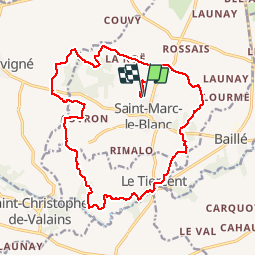
Saint marc le blanc 19km

COGLAIS3
User

Length
19.2 km

Max alt
116 m

Uphill gradient
219 m
Km-Effort
22 km

Min alt
59 m

Downhill gradient
220 m
Boucle
Yes
Creation date :
2019-12-03 07:11:29.023
Updated on :
2019-12-04 21:11:53.075
3h29
Difficulty : Easy

FREE GPS app for hiking
 SityTrail
IGN / Geographical institutes
SityTrail Plus
The world is yours!
About
Trail Nordic walking of 19.2 km to be discovered at Brittany, Ille-et-Vilaine, Saint-Marc-le-Blanc. This trail is proposed by COGLAIS3.
Description
Saint Marc le Blanc, Le Fretay, Brimenel, Le Tiercent, Les plessix.
Positioning
Country:
France
Region :
Brittany
Department/Province :
Ille-et-Vilaine
Municipality :
Saint-Marc-le-Blanc
Location:
Saint-Marc-le-Blanc
Start:(Dec)
Start:(UTM)
617724 ; 5358547 (30U) N.
Comments