Trail Walking Fontenay-le-Fleury - Fontenay le fleury - Photo
© OpenStreetMap contributors
Length
Length
18.2 km
Max alt
Max alt
188 m
Uphill gradient
Uphill gradient
214 m
Km-Effort
Km-Effort  
21 km
Min alt
Min alt
99 m
Downhill gradient
Downhill gradient
201 m
Boucle
Boucle
Yes
Creation date :
2019-12-03 09:10:28.825
Updated on :
2019-12-06 10:57:28.796

(0 Reviews)

Walking
Walking
5h15
Difficulty : Very easy

Scan this QR Code to open this trail in the SityTrail application

FREE GPS app for hiking

Logo SityTrail SityTrail

IGN / Geographical institutes

Download SityTrail from the App Store Download SityTrail from Google Play

Logo SityTrail SityTrail Plus

The world is yours!

Download SityTrail from the App Store Download SityTrail from Google Play Download SityTrail on Huawei AppGallery

About

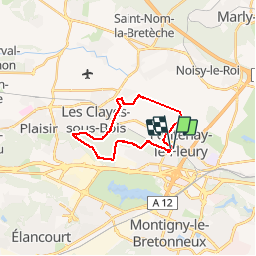
Trail Walking of 18.2 km to be discovered at Ile-de-France, Yvelines, Fontenay-le-Fleury. This trail is proposed by c.chehere.

Description

Départ depuis le parking de le gare de Fontenay le fleury.
En grosse partie balisé, début de la rando sur des chemins d'exploitation agricole assez gras en hiver. La suite en forêt . Préférer les pistes forestière en hiver pour éviter la boue

Elevation profile

Positioning

Country:
France
Region :
Ile-de-France
Department/Province :
Yvelines
Municipality :
Fontenay-le-Fleury
Location:
Unknown
Start:(UTM)
429538 ; 5406599 (31U) N.


Close
My subscriptions