


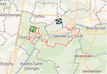
2019-12-05_09h57m00_SityTrail - 2220091 - chamarande-lardy-jpd-12-12-19

jpcccb
User

Length
14.3 km

Max alt
151 m

Uphill gradient
237 m
Km-Effort
17.5 km

Min alt
59 m

Downhill gradient
239 m
Boucle
No
Creation date :
2019-12-05 08:57:00.473
Updated on :
2023-05-09 12:15:13.22
3h58
Difficulty : Difficult

FREE GPS app for hiking
 SityTrail
IGN / Geographical institutes
SityTrail Plus
The world is yours!
About
Trail Walking of 14.3 km to be discovered at Ile-de-France, Essonne, Chamarande. This trail is proposed by jpcccb.
Description
Parc de Chamarande, château, belvédère, GR 655, Gillevoisin, bois de Pernaison, pierre levée, château du Mesnil Voisin, la Juine.
Positioning
Country:
France
Region :
Ile-de-France
Department/Province :
Essonne
Municipality :
Chamarande
Location:
Unknown
Start:(Dec)
Start:(UTM)
442125 ; 5373819 (31U) N.
Comments