


SityTrail - Trail des Trois Rocs 2016 partie 1

Jovila
User
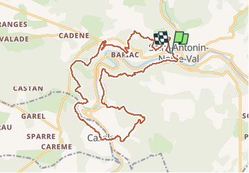

Length
24 km

Max alt
340 m

Uphill gradient
923 m
Km-Effort
36 km

Min alt
115 m

Downhill gradient
922 m
Boucle
Yes
Creation date :
2019-12-06 15:38:32.445
Updated on :
2020-05-19 18:26:05.654
--
Difficulty : Medium

FREE GPS app for hiking
 SityTrail
IGN / Geographical institutes
SityTrail Plus
The world is yours!
About
Trail Trail of 24 km to be discovered at Occitania, Tarn-et-Garonne, Saint-Antonin-Noble-Val. This trail is proposed by Jovila.
Description
Boucle sud-ouest St Anonin. Assez valonée permet une belle visite de ce coté de la vallée. (un petit detour par les grote est possible)
Positioning
Country:
France
Region :
Occitania
Department/Province :
Tarn-et-Garonne
Municipality :
Saint-Antonin-Noble-Val
Location:
Unknown
Start:(Dec)
Start:(UTM)
400205 ; 4889575 (31T) N.
Comments