


Move

tgvpatrickfavre
User

Length
23 km

Max alt
1124 m

Uphill gradient
1152 m
Km-Effort
38 km

Min alt
474 m

Downhill gradient
1155 m
Boucle
Yes
Creation date :
2019-12-07 11:36:28.091
Updated on :
2019-12-07 11:39:39.867
7h45
Difficulty : Medium

FREE GPS app for hiking
 SityTrail
IGN / Geographical institutes
SityTrail Plus
The world is yours!
About
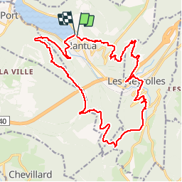
Trail Walking of 23 km to be discovered at Auvergne-Rhône-Alpes, Ain, Nantua. This trail is proposed by tgvpatrickfavre.
Description
départ esplanade , roche merveilleuse, grange des pauvres , descente sur les neyrolles , colliard , les monts d'ain le signal , la grange à l ours ,et retour à Nantua
Positioning
Country:
France
Region :
Auvergne-Rhône-Alpes
Department/Province :
Ain
Municipality :
Nantua
Location:
Unknown
Start:(Dec)
Start:(UTM)
701074 ; 5114747 (31T) N.
Comments