


051219 Vauvert

Dupuybadonniere
User
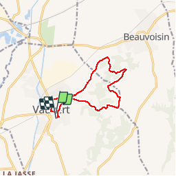

Length
11.4 km

Max alt
105 m

Uphill gradient
135 m
Km-Effort
13.2 km

Min alt
26 m

Downhill gradient
130 m
Boucle
Yes
Creation date :
2019-12-05 12:33:32.562
Updated on :
2019-12-08 13:18:44.354
3h32
Difficulty : Very easy

FREE GPS app for hiking
 SityTrail
IGN / Geographical institutes
SityTrail Plus
The world is yours!
About
Trail Walking of 11.4 km to be discovered at Occitania, Gard, Vauvert. This trail is proposed by Dupuybadonniere.
Positioning
Country:
France
Region :
Occitania
Department/Province :
Gard
Municipality :
Vauvert
Location:
Unknown
Start:(Dec)
Start:(UTM)
603020 ; 4838333 (31T) N.
Comments