


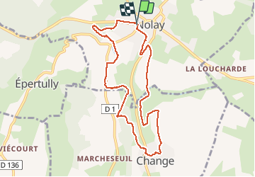
V2019 nolay rando douce 17.12

clabidault
User

Length
8.8 km

Max alt
341 m

Uphill gradient
139 m
Km-Effort
10.7 km

Min alt
286 m

Downhill gradient
139 m
Boucle
Yes
Creation date :
2019-12-09 12:35:54.076
Updated on :
2019-12-09 16:16:41.909
1h49
Difficulty : Very easy

FREE GPS app for hiking
 SityTrail
IGN / Geographical institutes
SityTrail Plus
The world is yours!
About
Trail Walking of 8.8 km to be discovered at Bourgogne-Franche-Comté, Côte-d'Or, Nolay. This trail is proposed by clabidault.
Positioning
Country:
France
Region :
Bourgogne-Franche-Comté
Department/Province :
Côte-d'Or
Municipality :
Nolay
Location:
Unknown
Start:(Dec)
Start:(UTM)
624039 ; 5201115 (31T) N.
Comments