


ROSIERES 11-12-2019

issartelserge
User
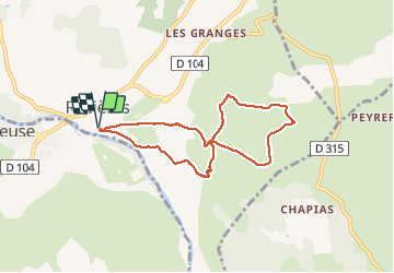

Length
7.4 km

Max alt
262 m

Uphill gradient
157 m
Km-Effort
9.5 km

Min alt
142 m

Downhill gradient
159 m
Boucle
Yes
Creation date :
2019-12-10 07:49:20.0
Updated on :
2019-12-11 04:40:14.657
3h04
Difficulty : Unknown

FREE GPS app for hiking
 SityTrail
IGN / Geographical institutes
SityTrail Plus
The world is yours!
About
Trail Walking of 7.4 km to be discovered at Auvergne-Rhône-Alpes, Ardèche, Rosières. This trail is proposed by issartelserge.
Description
Facile
Positioning
Country:
France
Region :
Auvergne-Rhône-Alpes
Department/Province :
Ardèche
Municipality :
Rosières
Location:
Unknown
Start:(Dec)
Start:(UTM)
599888 ; 4926009 (31T) N.
Comments