


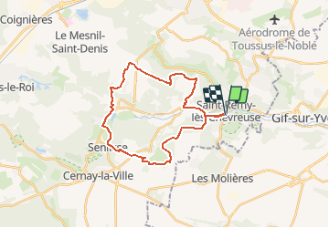
Châteaux en Vallée de Chevreuse

NUITEVEN
User

Length
26 km

Max alt
180 m

Uphill gradient
370 m
Km-Effort
30 km

Min alt
74 m

Downhill gradient
371 m
Boucle
Yes
Creation date :
2019-12-10 16:10:08.555
Updated on :
2020-02-12 16:11:06.534
6h08
Difficulty : Very difficult

FREE GPS app for hiking
 SityTrail
IGN / Geographical institutes
SityTrail Plus
The world is yours!
About
Trail Walking of 26 km to be discovered at Ile-de-France, Yvelines, Saint-Rémy-lès-Chevreuse. This trail is proposed by NUITEVEN.
Positioning
Country:
France
Region :
Ile-de-France
Department/Province :
Yvelines
Municipality :
Saint-Rémy-lès-Chevreuse
Location:
Unknown
Start:(Dec)
Start:(UTM)
431653 ; 5394873 (31U) N.
Comments
très belle promenade printanière dans les bois et à travers de paisibles communes champêtres. 15/05/2020