


thieure aspetjoc

raab
User
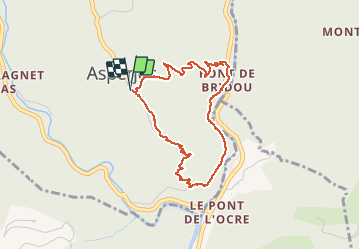

Length
3.8 km

Max alt
558 m

Uphill gradient
264 m
Km-Effort
7.3 km

Min alt
293 m

Downhill gradient
264 m
Boucle
Yes
Creation date :
2019-12-12 13:18:14.266
Updated on :
2019-12-12 15:15:55.536
1h57
Difficulty : Medium

FREE GPS app for hiking
 SityTrail
IGN / Geographical institutes
SityTrail Plus
The world is yours!
About
Trail Walking of 3.8 km to be discovered at Auvergne-Rhône-Alpes, Ardèche, Vallées-d'Antraigues-Asperjoc. This trail is proposed by raab.
Positioning
Country:
France
Region :
Auvergne-Rhône-Alpes
Department/Province :
Ardèche
Municipality :
Vallées-d'Antraigues-Asperjoc
Location:
Asperjoc
Start:(Dec)
Start:(UTM)
607715 ; 4948891 (31T) N.
Comments