


voinemont_12km

ZAMBAUX
User
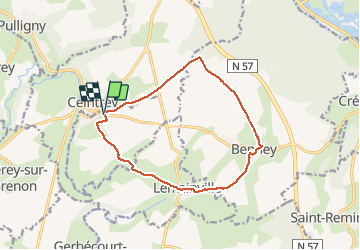

Length
12.1 km

Max alt
332 m

Uphill gradient
131 m
Km-Effort
13.9 km

Min alt
229 m

Downhill gradient
130 m
Boucle
Yes
Creation date :
2019-12-12 12:52:41.332
Updated on :
2019-12-12 15:36:52.792
2h43
Difficulty : Very easy

FREE GPS app for hiking
 SityTrail
IGN / Geographical institutes
SityTrail Plus
The world is yours!
About
Trail Walking of 12.1 km to be discovered at Grand Est, Meurthe-et-Moselle, Voinémont. This trail is proposed by ZAMBAUX.
Positioning
Country:
France
Region :
Grand Est
Department/Province :
Meurthe-et-Moselle
Municipality :
Voinémont
Location:
Unknown
Start:(Dec)
Start:(UTM)
290955 ; 5378176 (32U) N.
Comments