


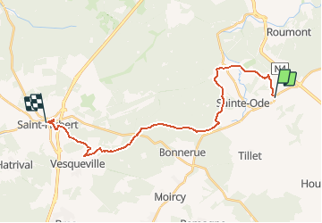
Transardennaise - Etape 2

guy284
User

Length
21 km

Max alt
565 m

Uphill gradient
518 m
Km-Effort
28 km

Min alt
362 m

Downhill gradient
464 m
Boucle
No
Creation date :
2019-12-13 20:30:03.196
Updated on :
2019-12-13 20:35:42.793
5h58
Difficulty : Very difficult

FREE GPS app for hiking
 SityTrail
IGN / Geographical institutes
SityTrail Plus
The world is yours!
About
Trail Walking of 21 km to be discovered at Wallonia, Luxembourg, Sainte-Ode. This trail is proposed by guy284.
Description
Sprimont - Saint Hubert
Positioning
Country:
Belgium
Region :
Wallonia
Department/Province :
Luxembourg
Municipality :
Sainte-Ode
Location:
Amberloup
Start:(Dec)
Start:(UTM)
682505 ; 5546012 (31U) N.
Comments