


Suresnes

petergole
User

Length
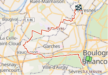
18.6 km

Max alt
174 m

Uphill gradient
303 m
Km-Effort
23 km

Min alt
28 m

Downhill gradient
282 m
Boucle
No
Creation date :
2019-12-15 08:38:24.0
Updated on :
2019-12-15 14:11:19.614
5h32
Difficulty : Unknown

FREE GPS app for hiking
 SityTrail
IGN / Geographical institutes
SityTrail Plus
The world is yours!
About
Trail Walking of 18.6 km to be discovered at Ile-de-France, Hauts-de-Seine, Sèvres. This trail is proposed by petergole.
Positioning
Country:
France
Region :
Ile-de-France
Department/Province :
Hauts-de-Seine
Municipality :
Sèvres
Location:
Unknown
Start:(Dec)
Start:(UTM)
443021 ; 5408764 (31U) N.
Comments