


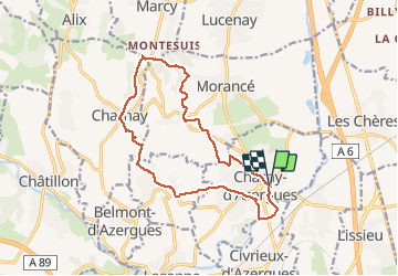
Chazay-d’Azergues

Galoche
User

Length
15.3 km

Max alt
445 m

Uphill gradient
373 m
Km-Effort
20 km

Min alt
187 m

Downhill gradient
373 m
Boucle
Yes
Creation date :
2019-12-16 07:51:28.0
Updated on :
2019-12-16 13:19:02.515
4h37
Difficulty : Medium

FREE GPS app for hiking
 SityTrail
IGN / Geographical institutes
SityTrail Plus
The world is yours!
About
Trail Walking of 15.3 km to be discovered at Auvergne-Rhône-Alpes, Rhône, Chazay-d'Azergues. This trail is proposed by Galoche.
Description
St Pierre Charnay Fontainebleau
15,2 km 375 m dénivelé
Positioning
Country:
France
Region :
Auvergne-Rhône-Alpes
Department/Province :
Rhône
Municipality :
Chazay-d'Azergues
Location:
Unknown
Start:(Dec)
Start:(UTM)
633030 ; 5081708 (31T) N.
Comments