


champlaittieŕparPASdüroc.

COMAN
User
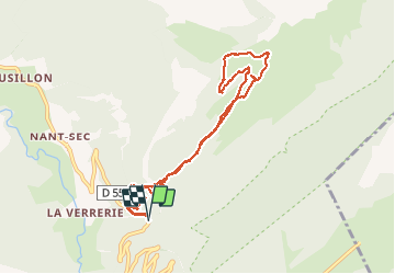

Length
11 km

Max alt
1516 m

Uphill gradient
709 m
Km-Effort
20 km

Min alt
923 m

Downhill gradient
710 m
Boucle
Yes
Creation date :
2019-12-17 09:03:25.831
Updated on :
2019-12-17 15:39:44.966
4h53
Difficulty : Medium

FREE GPS app for hiking
 SityTrail
IGN / Geographical institutes
SityTrail Plus
The world is yours!
About
Trail Walking of 11 km to be discovered at Auvergne-Rhône-Alpes, Upper Savoy, Fillière. This trail is proposed by COMAN.
Positioning
Country:
France
Region :
Auvergne-Rhône-Alpes
Department/Province :
Upper Savoy
Municipality :
Fillière
Location:
Thorens-Glières
Start:(Dec)
Start:(UTM)
290754 ; 5094167 (32T) N.
Comments