


SityTrail - Mirwart 10.1 km

renneph
User
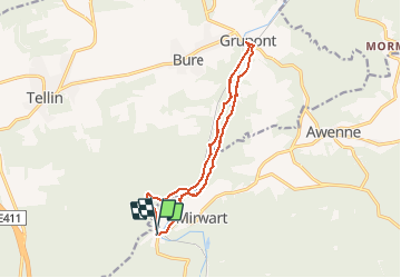

Length
11.9 km

Max alt
291 m

Uphill gradient
201 m
Km-Effort
14.6 km

Min alt
228 m

Downhill gradient
201 m
Boucle
Yes
Creation date :
2019-12-18 07:15:54.856
Updated on :
2020-01-23 15:54:16.942
3h09
Difficulty : Difficult

FREE GPS app for hiking
 SityTrail
IGN / Geographical institutes
SityTrail Plus
The world is yours!
About
Trail Walking of 11.9 km to be discovered at Wallonia, Luxembourg, Saint-Hubert. This trail is proposed by renneph.
Photos


Positioning
Country:
Belgium
Region :
Wallonia
Department/Province :
Luxembourg
Municipality :
Saint-Hubert
Location:
Mirwart
Start:(Dec)
Start:(UTM)
661187 ; 5547018 (31U) N.
Comments