


st chamond

benoitrando
User
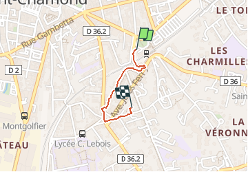

Length
731 m

Max alt
400 m

Uphill gradient
22 m
Km-Effort
951 m

Min alt
377 m

Downhill gradient
0 m
Boucle
No
Creation date :
2019-12-19 11:04:39.167
Updated on :
2019-12-19 11:21:05.244
16m
Difficulty : Very easy

FREE GPS app for hiking
 SityTrail
IGN / Geographical institutes
SityTrail Plus
The world is yours!
About
Trail Walking of 731 m to be discovered at Auvergne-Rhône-Alpes, Loire, Saint-Chamond. This trail is proposed by benoitrando.
Positioning
Country:
France
Region :
Auvergne-Rhône-Alpes
Department/Province :
Loire
Municipality :
Saint-Chamond
Location:
Unknown
Start:(Dec)
Start:(UTM)
618525 ; 5036567 (31T) N.
Comments