


21.12.2019 - Heiligenstein

delm
User
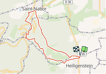

Length
8.8 km

Max alt
578 m

Uphill gradient
351 m
Km-Effort
13.4 km

Min alt
283 m

Downhill gradient
351 m
Boucle
Yes
Creation date :
2019-12-21 13:15:44.0
Updated on :
2019-12-21 15:51:38.954
2h35
Difficulty : Difficult

FREE GPS app for hiking
 SityTrail
IGN / Geographical institutes
SityTrail Plus
The world is yours!
About
Trail Walking of 8.8 km to be discovered at Grand Est, Bas-Rhin, Obernai. This trail is proposed by delm.
Description
Sympathique et agréable
Positioning
Country:
France
Region :
Grand Est
Department/Province :
Bas-Rhin
Municipality :
Obernai
Location:
Unknown
Start:(Dec)
Start:(UTM)
385444 ; 5365001 (32U) N.
Comments