


chapdes beaufort les ancizes

jeanic63
User

Length
22 km

Max alt
786 m

Uphill gradient
469 m
Km-Effort
28 km

Min alt
631 m

Downhill gradient
473 m
Boucle
Yes
Creation date :
2019-12-21 17:50:00.595
Updated on :
2021-12-21 17:28:43.412
--
Difficulty : Medium

FREE GPS app for hiking
 SityTrail
IGN / Geographical institutes
SityTrail Plus
The world is yours!
About
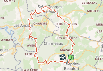
Trail On foot of 22 km to be discovered at Auvergne-Rhône-Alpes, Puy-de-Dôme, Chapdes-Beaufort. This trail is proposed by jeanic63.
Description
départ de chapdes beaufort vers l'eglise
Positioning
Country:
France
Region :
Auvergne-Rhône-Alpes
Department/Province :
Puy-de-Dôme
Municipality :
Chapdes-Beaufort
Location:
Unknown
Start:(Dec)
Start:(UTM)
489187 ; 5082126 (31T) N.
Comments