


191223 Mont St Guibert

guy284
User
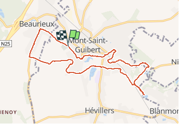

Length
9.6 km

Max alt
126 m

Uphill gradient
166 m
Km-Effort
11.8 km

Min alt
76 m

Downhill gradient
168 m
Boucle
Yes
Creation date :
2019-12-23 13:06:57.239
Updated on :
2019-12-23 15:27:33.847
2h19
Difficulty : Easy

FREE GPS app for hiking
 SityTrail
IGN / Geographical institutes
SityTrail Plus
The world is yours!
About
Trail Walking of 9.6 km to be discovered at Wallonia, Walloon Brabant, Mont-Saint-Guibert. This trail is proposed by guy284.
Positioning
Country:
Belgium
Region :
Wallonia
Department/Province :
Walloon Brabant
Municipality :
Mont-Saint-Guibert
Location:
Mont-Saint-Guibert
Start:(Dec)
Start:(UTM)
613561 ; 5610616 (31U) N.
Comments