


20191222

ludol
User
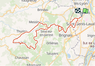

Length
51 km

Max alt
573 m

Uphill gradient
987 m
Km-Effort
64 km

Min alt
208 m

Downhill gradient
986 m
Boucle
Yes
Creation date :
2019-12-22 12:52:35.497
Updated on :
2019-12-26 07:35:31.85
4h17
Difficulty : Very easy

FREE GPS app for hiking
 SityTrail
IGN / Geographical institutes
SityTrail Plus
The world is yours!
About
Trail Mountain bike of 51 km to be discovered at Auvergne-Rhône-Alpes, Métropole de Lyon, Saint-Genis-Laval. This trail is proposed by ludol.
Positioning
Country:
France
Region :
Auvergne-Rhône-Alpes
Department/Province :
Métropole de Lyon
Municipality :
Saint-Genis-Laval
Location:
Unknown
Start:(Dec)
Start:(UTM)
639813 ; 5063149 (31T) N.
Comments