


reco melda

DaVinci
User
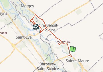

Length
15.4 km

Max alt
112 m

Uphill gradient
97 m
Km-Effort
16.7 km

Min alt
90 m

Downhill gradient
99 m
Boucle
No
Creation date :
2019-12-27 09:51:30.946
Updated on :
2019-12-27 13:25:23.235
1h35
Difficulty : Easy

FREE GPS app for hiking
 SityTrail
IGN / Geographical institutes
SityTrail Plus
The world is yours!
About
Trail Walking of 15.4 km to be discovered at Grand Est, Aube, Sainte-Maure. This trail is proposed by DaVinci.
Positioning
Country:
France
Region :
Grand Est
Department/Province :
Aube
Municipality :
Sainte-Maure
Location:
Unknown
Start:(Dec)
Start:(UTM)
578258 ; 5355367 (31U) N.
Comments