


Ski Gavarnie 27/12/19

cl56
User
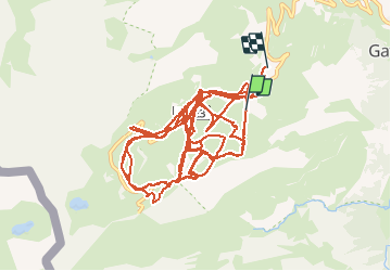

Length
41 km

Max alt
2292 m

Uphill gradient
4146 m
Km-Effort
96 km

Min alt
1821 m

Downhill gradient
4325 m
Boucle
No
Creation date :
2019-12-27 12:18:58.651
Updated on :
2019-12-27 16:44:27.229
3h55
Difficulty : Very easy

FREE GPS app for hiking
 SityTrail
IGN / Geographical institutes
SityTrail Plus
The world is yours!
About
Trail Alpine skiing of 41 km to be discovered at Occitania, Hautespyrenees, Gavarnie-Gèdre. This trail is proposed by cl56.
Positioning
Country:
France
Region :
Occitania
Department/Province :
Hautespyrenees
Municipality :
Gavarnie-Gèdre
Location:
Gavarnie
Start:(Dec)
Start:(UTM)
742832 ; 4734576 (30T) N.
Comments