


Source du Lez DFCI rive droite

DiagMan
User
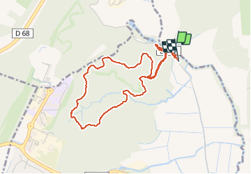

Length
4.6 km

Max alt
122 m

Uphill gradient
67 m
Km-Effort
5.5 km

Min alt
65 m

Downhill gradient
72 m
Boucle
Yes
Creation date :
2019-12-29 13:18:14.066
Updated on :
2019-12-29 14:26:36.886
1h07
Difficulty : Very easy

FREE GPS app for hiking
 SityTrail
IGN / Geographical institutes
SityTrail Plus
The world is yours!
About
Trail Walking of 4.6 km to be discovered at Occitania, Hérault, Saint-Clément-de-Rivière. This trail is proposed by DiagMan.
Positioning
Country:
France
Region :
Occitania
Department/Province :
Hérault
Municipality :
Saint-Clément-de-Rivière
Location:
Unknown
Start:(Dec)
Start:(UTM)
568427 ; 4840628 (31T) N.
Comments
petite balade sympa