Trail Walking Nice - Vieux Nice-St Jean Cap Ferrat-Vieux Nice  - Photo

Vieux Nice-St Jean Cap Ferrat-Vieux Nice

 coriace
coriace

User

© OpenStreetMap contributors
Length
Length
31 km
Max alt
Max alt
90 m
Uphill gradient
Uphill gradient
593 m
Km-Effort
Km-Effort  
38 km
Min alt
Min alt
-1 m
Downhill gradient
Downhill gradient
576 m
Boucle
Boucle
No
Creation date :
2019-12-28 12:18:55.974
Updated on :
2019-12-29 15:44:44.818

(0 Reviews)

Walking
Walking
4h14
Difficulty : Very easy

Scan this QR Code to open this trail in the SityTrail application

FREE GPS app for hiking

Logo SityTrail SityTrail

IGN / Geographical institutes

Download SityTrail from the App Store Download SityTrail from Google Play

Logo SityTrail SityTrail Plus

The world is yours!

Download SityTrail from the App Store Download SityTrail from Google Play Download SityTrail on Huawei AppGallery

About

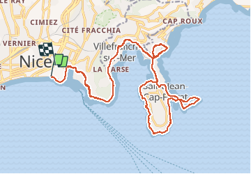
Trail Walking of 31 km to be discovered at Provence-Alpes-Côte d'Azur, Maritime Alps, Nice. This trail is proposed by coriace.

Description

Départ vieux Nice à pied. Prendre bus du port de Nice. Arrêt Passable/Rotschild. Marche bord du littoral (kms). Prendre bus port de st Jean jusqu'à place Garibaldi. soit 20 kms en bus aller-retour et 10 kms de marche au total.

Elevation profile

Positioning

Country:
France
Region :
Provence-Alpes-Côte d'Azur
Department/Province :
Maritime Alps
Municipality :
Nice
Location:
Unknown
Start:(UTM)
361117 ; 4839483 (32T) N.


Close
My subscriptions