


Chasselay

Coux
User
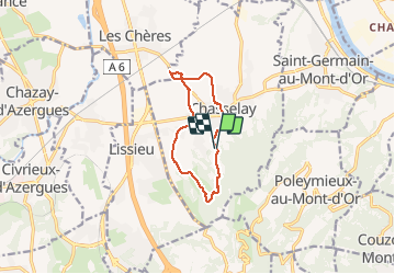

Length
9.4 km

Max alt
401 m

Uphill gradient
203 m
Km-Effort
12.2 km

Min alt
203 m

Downhill gradient
212 m
Boucle
Yes
Creation date :
2019-12-15 08:06:52.808
Updated on :
2019-12-30 11:49:02.228
2h42
Difficulty : Very easy

FREE GPS app for hiking
 SityTrail
IGN / Geographical institutes
SityTrail Plus
The world is yours!
About
Trail Walking of 9.4 km to be discovered at Auvergne-Rhône-Alpes, Rhône, Chasselay. This trail is proposed by Coux.
Photos

Positioning
Country:
France
Region :
Auvergne-Rhône-Alpes
Department/Province :
Rhône
Municipality :
Chasselay
Location:
Unknown
Start:(Dec)
Start:(UTM)
637332 ; 5080624 (31T) N.
Comments