vallangpujat

Dayoff
User
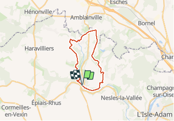

Length
19.7 km

Max alt
130 m

Uphill gradient
275 m
Km-Effort
23 km

Min alt
44 m

Downhill gradient
274 m
Boucle
Yes
Creation date :
2020-01-02 08:25:38.961
Updated on :
2020-01-02 13:53:09.602
5h25
Difficulty : Easy

FREE GPS app for hiking
 SityTrail
IGN / Geographical institutes
SityTrail Plus
The world is yours!
About
Trail Walking of 19.7 km to be discovered at Ile-de-France, Val-d'Oise, Vallangoujard. This trail is proposed by Dayoff.
Positioning
Country:
France
Region :
Ile-de-France
Department/Province :
Val-d'Oise
Municipality :
Vallangoujard
Location:
Unknown
Start:(Dec)
Start:(UTM)
435517 ; 5443305 (31U) N.
Comments