


Villeneuve Mont Chabaud 5km

thonyc
User GUIDE
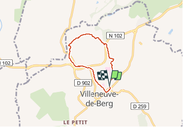

Length
4.8 km

Max alt
344 m

Uphill gradient
154 m
Km-Effort
6.9 km

Min alt
219 m

Downhill gradient
149 m
Boucle
Yes
Creation date :
2020-01-03 12:51:58.255
Updated on :
2020-01-03 17:15:58.213
1h30
Difficulty : Easy

FREE GPS app for hiking
 SityTrail
IGN / Geographical institutes
SityTrail Plus
The world is yours!
About
Trail Walking of 4.8 km to be discovered at Auvergne-Rhône-Alpes, Ardèche, Villeneuve-de-Berg. This trail is proposed by thonyc.
Positioning
Country:
France
Region :
Auvergne-Rhône-Alpes
Department/Province :
Ardèche
Municipality :
Villeneuve-de-Berg
Location:
Unknown
Start:(Dec)
Start:(UTM)
619286 ; 4934996 (31T) N.
Comments