


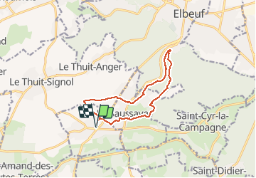
20200104-St Pierre des Fleurs

doudet
User

Length
11.3 km

Max alt
152 m

Uphill gradient
143 m
Km-Effort
13.2 km

Min alt
58 m

Downhill gradient
143 m
Boucle
Yes
Creation date :
2020-01-04 12:32:17.878
Updated on :
2020-01-06 10:30:03.458
2h59
Difficulty : Easy

FREE GPS app for hiking
 SityTrail
IGN / Geographical institutes
SityTrail Plus
The world is yours!
About
Trail Walking of 11.3 km to be discovered at Normandy, Eure, Saint-Pierre-des-Fleurs. This trail is proposed by doudet.
Description
Boucle A-R au départ de l'Eglise
Positioning
Country:
France
Region :
Normandy
Department/Province :
Eure
Municipality :
Saint-Pierre-des-Fleurs
Location:
Unknown
Start:(Dec)
Start:(UTM)
351985 ; 5457355 (31U) N.
Comments