


Orrys de Belcaire, Mont Hourre-refuge de Gaffouil- Orrys de Casque

petit-pied
User
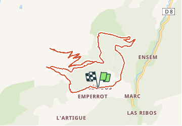

Length
14.1 km

Max alt
2040 m

Uphill gradient
991 m
Km-Effort
27 km

Min alt
1212 m

Downhill gradient
991 m
Boucle
Yes
Creation date :
2020-01-04 20:34:18.021
Updated on :
2020-01-04 20:35:37.694
5h27
Difficulty : Very difficult

FREE GPS app for hiking
 SityTrail
IGN / Geographical institutes
SityTrail Plus
The world is yours!
About
Trail Walking of 14.1 km to be discovered at Occitania, Ariège, Auzat. This trail is proposed by petit-pied.
Positioning
Country:
France
Region :
Occitania
Department/Province :
Ariège
Municipality :
Auzat
Location:
Unknown
Start:(Dec)
Start:(UTM)
372021 ; 4730788 (31T) N.
Comments