la goulandiere depuis la balme de rencurel

guyzinz
User
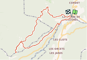

Length
10.9 km

Max alt
1116 m

Uphill gradient
570 m
Km-Effort
18.5 km

Min alt
657 m

Downhill gradient
561 m
Boucle
Yes
Creation date :
2020-01-05 08:33:19.033
Updated on :
2020-01-05 13:20:36.524
4h25
Difficulty : Easy

FREE GPS app for hiking
 SityTrail
IGN / Geographical institutes
SityTrail Plus
The world is yours!
About
Trail Walking of 10.9 km to be discovered at Auvergne-Rhône-Alpes, Isère, Rencurel. This trail is proposed by guyzinz.
Positioning
Country:
France
Region :
Auvergne-Rhône-Alpes
Department/Province :
Isère
Municipality :
Rencurel
Location:
Unknown
Start:(Dec)
Start:(UTM)
694203 ; 4995717 (31T) N.
Comments