


st veran

Coux
User
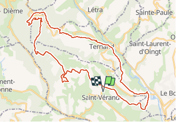

Length
26 km

Max alt
750 m

Uphill gradient
982 m
Km-Effort
39 km

Min alt
259 m

Downhill gradient
982 m
Boucle
Yes
Creation date :
2020-01-05 07:57:32.785
Updated on :
2020-01-05 14:24:46.283
6h24
Difficulty : Difficult

FREE GPS app for hiking
 SityTrail
IGN / Geographical institutes
SityTrail Plus
The world is yours!
About
Trail Walking of 26 km to be discovered at Auvergne-Rhône-Alpes, Rhône, Saint-Vérand. This trail is proposed by Coux.
Positioning
Country:
France
Region :
Auvergne-Rhône-Alpes
Department/Province :
Rhône
Municipality :
Saint-Vérand
Location:
Unknown
Start:(Dec)
Start:(UTM)
618633 ; 5086500 (31T) N.
Comments