


jenneret ac 2

colsonandre
User
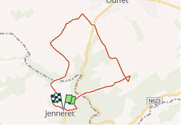

Length
7.9 km

Max alt
284 m

Uphill gradient
183 m
Km-Effort
10.3 km

Min alt
190 m

Downhill gradient
179 m
Boucle
Yes
Creation date :
2020-01-06 12:37:27.332
Updated on :
2020-03-08 16:45:47.769
2h19
Difficulty : Medium

FREE GPS app for hiking
 SityTrail
IGN / Geographical institutes
SityTrail Plus
The world is yours!
About
Trail Walking of 7.9 km to be discovered at Wallonia, Luxembourg, Durbuy. This trail is proposed by colsonandre.
Description
très belle
Positioning
Country:
Belgium
Region :
Wallonia
Department/Province :
Luxembourg
Municipality :
Durbuy
Location:
Bende
Start:(Dec)
Start:(UTM)
673847 ; 5587462 (31U) N.
Comments