


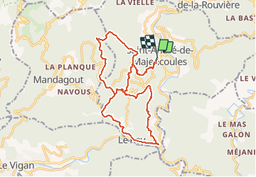
les grandes collines à partir de St André de majencoules

labarone
User

Length
21 km

Max alt
713 m

Uphill gradient
1036 m
Km-Effort
35 km

Min alt
199 m

Downhill gradient
1036 m
Boucle
Yes
Creation date :
2020-01-07 08:23:28.27
Updated on :
2020-01-07 15:36:43.672
6h36
Difficulty : Medium

FREE GPS app for hiking
 SityTrail
IGN / Geographical institutes
SityTrail Plus
The world is yours!
About
Trail Walking of 21 km to be discovered at Occitania, Gard, Saint-André-de-Majencoules. This trail is proposed by labarone.
Description
À mi chemin table pour pique nique. Deuxième partie plus beau paysage
Photos


Positioning
Country:
France
Region :
Occitania
Department/Province :
Gard
Municipality :
Saint-André-de-Majencoules
Location:
Unknown
Start:(Dec)
Start:(UTM)
553992 ; 4875150 (31T) N.
Comments