


2020-01-07_17h46m14_SDF Gare Jouy Nesles Valmondois retour

avdem
User
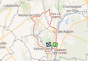

Length
13.6 km

Max alt
105 m

Uphill gradient
152 m
Km-Effort
15.6 km

Min alt
23 m

Downhill gradient
153 m
Boucle
Yes
Creation date :
2020-01-07 16:46:18.345
Updated on :
2020-01-07 16:46:23.259

FREE GPS app for hiking
 SityTrail
IGN / Geographical institutes
SityTrail Plus
The world is yours!
About
Trail of 13.6 km to be discovered at Ile-de-France, Val-d'Oise, Parmain. This trail is proposed by avdem.
Positioning
Country:
France
Region :
Ile-de-France
Department/Province :
Val-d'Oise
Municipality :
Parmain
Location:
Unknown
Start:(Dec)
Start:(UTM)
441774 ; 5438366 (31U) N.
Comments