


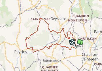
marche De la galette des tous à Triors

okfred26
User

Length
19.5 km

Max alt
433 m

Uphill gradient
504 m
Km-Effort
26 km

Min alt
204 m

Downhill gradient
504 m
Boucle
Yes
Creation date :
2020-01-05 08:06:40.147
Updated on :
2020-01-09 20:12:42.317
5h23
Difficulty : Very easy

FREE GPS app for hiking
 SityTrail
IGN / Geographical institutes
SityTrail Plus
The world is yours!
About
Trail Walking of 19.5 km to be discovered at Auvergne-Rhône-Alpes, Drôme, Triors. This trail is proposed by okfred26.
Positioning
Country:
France
Region :
Auvergne-Rhône-Alpes
Department/Province :
Drôme
Municipality :
Triors
Location:
Unknown
Start:(Dec)
Start:(UTM)
666445 ; 4995695 (31T) N.
Comments